~ Mother Earth ~
-
Dedicated to our one and only home...planet Earth

-
Geography
Geography is a science that deals with the distribution and arrangement of all elements of the earth's surface. The word geography was adopted in the 200s BC by the Greek scholar Eratosthenes and means “earth description.”
Geographic study encompasses the environment of the earth's surface and the relationship of humans to this environment, which includes both physical and cultural geographic features. Physical geographic features include the climate, land and water, and plant and animal life. Cultural geographic features include artificial entities, such as nations, settlements, lines of communication, transportation, buildings, and other modifications of the physical geographic environment. Geographers use economics, history, biology, geology, and mathematics in their studies.
Physical map of the Earth
Issue #1 -
Richat Structure
The Richat Structure, a prominent circular feature in the Sahara desert of Mauritania, has attracted attention since the earliest space missions because it forms a conspicuous bullÂ’s-eye in the otherwise rather featureless expanse of the desert.
Satellite picture of the Richat Structure
Described by some as looking like an outsized ammonite in the desert, the structure, which has a diameter of almost 50 kilometers (30 miles), has become a landmark for shuttle crews. Initially interpreted as a meteorite impact structure because of its high degree of circularity, it is now thought to be merely a symmetrical uplift (circular anticline) that has been laid bare by erosion. Paleozoic quartzites form the resistant beds outlining the structure.
Issue #2 -
geography lessons!
/takes chair.. sit down n read
-
you know why is it call mother earth and not father earth? becuz you can only see round round and not see a ball with a stick out~

-
/take pen
/take paper -
Death Valley
Death Valley is a deep arid basin in the northern Mojave Desert of southern California in the United States, extending for approximately 140 mi (225 km) along the California-Nevada border approximately 100 mi (160 km) west of Las Vegas. Famous for its brutal extremes of heat, the valley floor at Badwater Basin is the location of the lowest point in the Western Hemisphere (N36° 13.961' W116° 46.700'), at 282 feet (86 m) below sea level. The entire valley is located within Death Valley National Park.
The valley is located southeast of the Sierra Nevada range in the Great Basin. It is bounded on the east by the Grapevine Mountains, Funeral Mountains, and Amargosa Range. It is bounded on the west by the Cottonwood Mountains and the Panamint Range. The geological configuration is considered one of the best examples of the Basin and Range configuration.
The Panamint Range, Death Valley, and the Black Mountains as seen from the Space Shuttle (NASA image)
The valley radiates extreme amounts of heat, allowing for temperatures that are among the hottest on earth. The hottest temperature recorded in the U.S., and the second hottest in the world, was 134°F (56.6°C) at Greenland Ranch near the valley on July 10, 1913. The valley receives less than 2 in (5 cm) of rain annually. The Amargosa River and Furnace Creek flow through the valley, disappearing into the sands of the valley floor.
While there is very little rain in Death Valley, the valley is prone to flooding during heavy rains, because the soil is unable to absorb the bulk of the water. The runoff can produce dangerous flash floods. In August 2004 such flooding occurred, causing two deaths and shutting down the national park.
During the late Pleistocene, the valley was indundated by prehistoric Lake Manly. The valley received its name in 1849 during the California gold rush by emigrants who sought to cross the valley on their way to the gold fields. During the 1850s, gold and silver were extracted in the valley. In the 1880s borax was discovered and extracted by mule-drawn wagons.
This False-color radar image shows central Death Valley and the different surface types in the area. Radar is sensitive to surface roughness with rough areas showing up brighter than smooth areas, which appear dark. This is seen in the contrast between the bright mountains that surround the dark, smooth basins and valleys of Death Valley. The image shows Furnace Creek alluvial fan (green crescent feature) at the far right, and the sand dunes near Stove Pipe Wells at the center. (NASA image)
Native population
Death Valley is home to the Timbisha tribe, who have inhabited the valley for at least the past 1,000 years. Some families still live in the valley at Indian Village. The name of the valley, tümpisa, means 'rock paint' and refers to the valley as a source of red ochre paint. Another village in the valley was located in Grapevine Canyon near the present site of Scotty's Castle. It was called maahunu, the meaning of which is uncertain although hunu means 'canyon'.
Issue #3 -
El Niño
El Niño and La Niña (often written in English as El Nino and La Nina) and are major temperature fluctuations in the tropical Pacific Ocean. They are Pacific signatures of the global ENSO phenomenon (El Niño-Southern Oscillation). Their effect on climate in the southern hemisphere is profound. Their role in global warming or cooling is an area of active research, with no clear consensus yet.
Chart of ocean surface temperature anomaly [°C] during the last strong El Niño in December 1997.
El Niño
El Niño was originally recognized by fishermen off the coast of South America (Peru and Ecuador) as the appearance of unusually warm water in the Pacific Ocean. El Niño is the warming of the surface waters of the eastern equatorial Pacific Ocean that occurs at irregular intervals of 2-7 years, usually lasting 1-2 years. Along the west coast of South America near the end of each calendar year, a warm current of nutrient-poor tropical water replaces the cold, nutrient-rich surface water of the Humboldt Current which fish prefer. Because this condition often occurs around Christmas, local fishermen named it El Niño (Spanish for boy child, referring to the Child Jesus). In most years the warming lasts only a few weeks or a month, after which the weather patterns return to normal and fishing improves. However, when El Niño conditions last for many months, more extensive ocean warming occurs and economic results can be disastrous.
Recent El Niños have occurred in 1986-1987, 1991-1992, 1993, 1994, 1997-1998, 2002-2003, and a new El Niño has been in effect since September 2004. The El Niño of 1997-1998 was particularly strong, while the period from 1990-1994 was unusual in that El Niños rarely occur in such rapid succession. They were generally weak, however.
ENSO/El Niño state.
- Sea surface is warm in central and eastern Pacific.
- Less cold water is pulled up along west coast of South America.
- Hot air rises in central Pacific, travels east and west before cooling and descending.
ENSO normal state.
- Normal equatorial winds warm as they flow westward across the Pacific.
- Cold water is pulled up along west coast of South America.
- Warming water is pushed toward west side of Pacific.
- Sea surface is warm in the west.
- Hot air rises in western Pacific, travels eastward and cool air descends on South America.
ENSO/La Niña state.
- Similar to ENSO normal state.
- Warm water accumulates in far western Pacific.
- Equatorial water is cooler than in the normal state.
El Niño's effects
El Niño's weather effects depend on the location, time of year, and the particular episode. In North America, typically, winters are warmer than normal in the upper midwest states and Canada, while central and southern California, northwest Mexico and the southeastern U.S., are wetter than normal. The Pacific Northwest states, on the other hand, tend to be drier during an El Niño. During a La Niña, by contrast, the midwestern U.S. tends to be drier than normal.
In South America, the effects of El Niño are rather direct and stronger than in North America. An El Niño is associated with very wet summers in the coasts of Northern Peru and Ecuador causing major flooding whenever the event is strong or extreme. The effects during the months of February, March and April may become critical. Southern Brazil and Northern Argentina also experience wetter than normal conditions but mainly during the spring and early summer. Central Chile receives large rainfall during winter, and the Peruvian-Bolivian Altiplano is sometimes exposed to unusual winter snowfall events. The entire peruvian coast and parts of northern Chile experience above-normal temperatures and moist conditions for several consecutive months as well. Drier and hotter weather occurs in parts the Amazon River Basin, Colombia and Central America.
Australia and Indonesia experience as well direct effects of El Niño resulting in drier conditions, especially in Indonesia and along the eastern half of Australia.
Finally, Africa experiences droughts both in the Sahel region (northwest Africa) and in south-central Africa (Zambia, Zimbabwe, Mozambique and Botswana mainly).
Non-climate effects
Along the west coast of South America, El Niño reduces the upwelling of cold, nutrient-rich water that sustains large fish populations, that sustain abundant sea birds, whose droppings support the fertilizer industry. The local fishing industry, who named the annual appearance near Christmas of the El Niño effect, along the affected coastline suffers greatly during long-lasting El Niño events.
La Niña
In the Pacific, La Niña is characterized by unusually cold ocean temperatures in the Equatorial Pacific, compared to El Niño, which is characterized by unusually warm ocean temperatures in the same area. The La Niña condition often follows the El Niño, especially when the latter is strong. Strong La Niñas occurred in 1988-1989 and 1998-2001, and weakly in 1995-1996.
SOI
The Southern Oscillation (SO) is a global-scale seesaw in atmospheric pressure between Indonesia/North Australia, and the southeast Pacific. Its measure is through the Southern Oscillation Index (SOI). The SOI is the normalised difference in surface pressure between Tahiti and Darwin.
SOI index, 1876-2004. By William M. Connolley.
Red: monthly averages; Blue: 12 month running mean
ENSO
ENSO (El Niño, Southern Oscillation) is a set of interacting parts of a single global system of climate fluctuations that come about as a consequence of atmospheric circulation. ENSO is the most prominent known source of interannual variability in weather and climate around the world (~3 to 8 years), though not all areas are affected. Global ENSO has signatures in the Pacific, Atlantic and Indian Oceans. In the Pacific, during major warm events El Niño warming extends over much of the tropical Pacific and becomes clearly linked to the SOI intensity. While ENSO events are basically in phase between the Pacific and Indian Oceans, ENSO events in the Atlantic Ocean lag those in the Pacific by 12-to-18 months. Many of the countries most affected by ENSO events are developing countries within main continents (South America, Africa...), with economies that are largely dependent upon their agricultural and fishery sectors as a major source of food supply, employment, and foreign exchange. New capabilities to predict the onset of ENSO events in the three oceans can have global socio-economical impacts. While ENSO is a global and natural part of the Earth's climate, whether its intensity or frequency may change as a result of global warming is an important concern. Low-frequency variability has been evidenced. Interdecadal modulation of ENSO might exist.
Western Hemisphere Warm Pool
Study of climate records has found that about half of the summers after an El Niño have unusual warming in the Western Hemisphere Warm Pool (WHWP). This affects weather in the area and seems to be related to the North Atlantic Oscillation.
Atlantic effect
An effect similar to El Niño sometimes takes place in the Atlantic Ocean, where water along equatorial Africa's Gulf of Guinea becomes warmer and eastern Brazil becomes cooler and drier. This may be related to El Niño Walker circulation changes over South America.
Issue #4 -
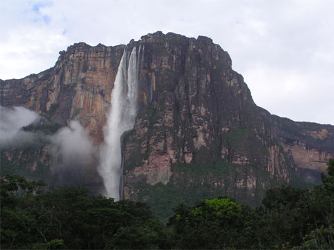
Angel Falls
Angel Falls or Salto Angel is the world's highest free-falling waterfall at 978 metres (3,212 feet) with an uninterrupted drop of 807 metres (2,647 feet). It is located on an unnamed tributary of the Rio Caroni, in the Canaima National Park, Venezuela.
Angel Falls or Salto Angel
Although first sighted in the early 20th century by the explorer Ernesto de Santa Cruz, the waterfall was not known to the world until its official discovery by the American aviator, James Crawford Angel, on a flight whilst searching for gold. Angel was born in Springfield, Missouri in 1899.
The official height was determined by a National Geographic Society survey in 1949 (see Jungle Journey to the World's Highest Waterfall by Ruth Robertson). David Mott's book, Angels Four, chronicles the first successful climb up the face of Ayan Tepui (Devil's Mountain) to the top of the falls. The falls are one of Venezuela's top tourist attractions.
Issue #5 -
Deception Island
Deception Island is an island in the South Shetland Islands off the Antarctic Peninsula in Antarctica. It is notable for having one of the safest harbors in Antarctica, and for being an active volcano, whose eruption in 1970 caused serious damage to the scientific stations there.
Entrance to Deception Island, taken January, 2003. Livingston Island is seen behind and to the right.
The island is located at 62 deg 57 min S, 60 deg 36 min W. It is approximately circular, with a diameter of about 12 km (7 mi), and its highest point, Mt Pond, has an elevation of 542 m (1778 ft). The center of the island is a large bay named Port Foster, about 9 km (5.5 mi) long and 6 km (3.6 mi) wide, thus covering most of the middle of the island. The bay has a narrow entrance, just 230 m (754 ft) wide, called Neptunes Bellows. Adding to the hazard is Ravn Rock, which lies 2.5 m (8 ft) below the water in the middle of the channel. Just inside Neptunes Bellows lies the cove Whalers Bay, which is bordered by a large black sand beach.
Nevertheless, since the early 19th century Deception Island was a favorite refuge from the storms and icebergs of Antarctica. It was first used by sealers, then in 1906 a Norwegian-Chilean whaling company started using Whalers Bay as a base for a factory ship, the Gobernador Bories. Other whaling operations followed suit, and by 1914 there were 13 factory ships based there.
The station did not actually process whale blubber, that being done on the ships, but instead took the carcasses and boiled them down to extract additional whale oil, using large iron boilers, and storing the results in iron tanks.
Whale oil prices dropped in the Great Depression, making the station uneconomic, and it was abandoned in 1931. Advances in factory ships made shore stations for carcass processing unnecessary, and so it was never reoccupied. 45 men were buried in the station's cemetery, but the cemetery was buried in a 1969 eruption, and the only remaining signs are the rusting boilers and tanks.
Other remains at Whalers Bay include an aircraft hangar with a bright orange derelict airplane fuselage outside, and the British scientific station house, with the middle torn out by the mudflows in 1969.
In the 1940s and 1950s, Argentina and the UK contested control of Deception Island with various tit-for-tat removals of each other's flags, and temporary occupation of the island.
On February 3, 1944 the British established a permanent base on Deception Island as part of Operation Tabarin, which was occupied until December 5, 1967, when a volcanic eruption forced a temporary withdrawal. It was used again between December 4, 1968 and Feburay 23, 1969, when further volcanic activity caused it to be abandoned.
British Deception Island station
In 1961 Argentina's president Arturo Frondizi visited to show his country's interest.
The volcano has mostly taken care of other attempts to maintain permanent facilities, and as of 2000, there were only two scientific stations still in use, both summer-only - Spain has Gabriel de Castilla, and Argentina its Decepcion station.
Ecology
Deception Island has several colonies of chinstrap penguins, and it is possible to make a warm bath by digging into the sands of the beach, so it has become a popular tourist stop in Antarctica.
Issue #6 -
Cape of Good Hope
The Cape of Good Hope is a headland in South Africa, near Cape Town, traditionally — and incorrectly — regarded as marking the turning point between the Atlantic Ocean and the Indian Ocean. (Technically, the division between the two oceans lies further south-east at Cape Agulhas)
The cold Benguela current on the West coast and the warm Agulhas current merge off the cape of Good Hope, which, along with the nearby Cape Point offers spectacular scenery.
The Cape of Good Hope headland seen from the north. Ostriches in front of Cape of Good Hope, Cape National Park, South Africa.
History
The Cape of Good Hope was first rounded by Portuguese navigator Bartolomeu Dias in 1488, who named it "Cape of Storms" (Cabo das Tormentas). It was later renamed by John II of Portugal as "Cape of Good Hope" (Cabo da Boa Esperança) because of the opening of a route to the east.
1888 Map of Capetown and the Cape of Good Hope
Dutch merchant Jan van Riebeeck established a resupply camp for the Dutch East India Company near the Cape on April 6, 1652 which eventually developed into Cape Town.
On December 31, 1687 a band of Huguenots were sent to the Cape from the Netherlands. They had escaped to the Netherlands from France in order to flee religious persecution there. The Dutch East India Company needed skilled farmers at the Cape of Good Hope, and the Netherlands Government saw opportunities for the Huguenots at the Cape and sent them over.
The United Kingdom on January 19, 1806, occupied the Cape. It was ceded to the UK in the Anglo-Dutch Treaty of 1814 and was henceforth administered as the Cape Colony.
Cape Triangular Postage Stamp


Issue #7 -
Golden Gate Bridge
The Golden Gate Bridge is a suspension bridge spanning the Golden Gate, the opening into the San Francisco Bay from the Pacific Ocean. It connects the city of San Francisco on the northern tip of the San Francisco Peninsula and a portion of the south-facing Marin County headlands near the small bayside town of Sausalito, and is located at 37°49' N 122°29' W. The color of the bridge is orange vermilion, deemed International Orange. The color was selected by consulting architect Irving Morrow because it blends well with the natural surroundings yet enhances the bridge's visibility.
The Golden Gate Bridge. View to the northwest, towards the Marin headlands.
Completed in 1937, it is widely considered one of the most beautiful examples of bridge engineering, both as an structural design challenge and for its aesthetic appeal. Its center span was the longest among suspension bridges until 1964 when the Verrazano Narrows Bridge was erected between the boroughs of Staten Island and Brooklyn in New York City. In 1957, Michigan's Mackinac Bridge surpassed the Golden Gate Bridge's length between anchorages to become the world's longest suspension bridge in total length. The longest center suspension span in the world is currently the Akashi-Kaikyo Bridge in Japan.
The bridge was the brainchild of Joseph Strauss, an engineer responsible for over 400 drawbridges, though they were far smaller than this project and mostly inland. Strauss spent over a decade drumming up support in Northern California. Strauss's initial proposal for this location was not at all pretty, being comprised of a massive cantilever on each side connected with a central suspension segment. Other key figures in the bridge's construction include architect Irving Morrow, responsible for the Art Deco touches and the choice of color, and engineer Charles Alton Ellis and bridge designer Leon Moisseiff, who collaborated on the complicated mathematics.
The construction of the bridge began on January 5, 1933 under the aegis of the Works Projects Administration (WPA), a program instigated by Franklin D. Roosevelt to create public works through federal funds and alleviate the effects of the Great Depression. It was completed in April 1937 and opened to pedestrians on May 27 of that year. The next day, President Roosevelt pushed a button in Washington, DC signaling the start of vehicle traffic over the Bridge. The cost to build it was $27 million. A unique aspect of the construction of this bridge was that a safety net was set up beneath it, significantly reducing the number of deaths that were typical for a construction project such as this in the early 1900s. Approximately 11 men were killed from falls during construction, and approximately 19 men were saved by the safety net. Most of the deaths occurred near completion when the net itself failed under the stress of a scaffold fall. Workers whose lives were saved by the safety nets became proud members of the (informal) Halfway to Hell Club.
The bridge is 1.22 miles (1970 m) long, the distance between the towers ("main span") is 4200 ft (1280 m), and their height is 746 feet (230 m) above the water.
Golden Gate Bridge with its approach arch over Fort Point at the San Francisco terminus
The bridge has been declared one of the modern Wonders of the World by the American Society of Civil Engineers. It was for many years the suspension bridge with the longest main span in the world, but was superseded by the 1298 m long Verrazano Narrows Bridge, New York City in 1964, and several other bridges since. It also had the world's tallest suspension towers at the time of construction, and retained that record until more recently.
Why isn't the bridge gold, as its name would suggest? International orange, the color of the bridge's paint, was chosen for its visibility in fog. The phrase Golden Gate refers to the strait that the bridge crosses, and this name predates the bridge.
As the only road to exit San Francisco to the north, the bridge is part of both United States Highway 101 and California State Route 1. The bridge has six total lanes of vehicle traffic, and walkways on both sides of the bridge. The median markers between the lanes are moved to conform to traffic patterns. On weekday mornings, traffic flows mostly southbound into the city, so four of the six lanes run southbound. Conversely, on weekday afternoons, four lanes run northbound. While there has been much demand and discussion concerning the installation of a movable barrier, no satisfactory solution has been committed to by the authorities. Usually, the eastern walkway is for pedestrians only, and the western walkway is for bicyclists only, although this can change during times of construction. Both walkways are closed to pedestrian traffic during the evening and at night.
The Golden Gate Bridge by night, with downtown San Francisco in the background at far left.
On September 1, 2002, the toll for southbound motor vehicles was raised from $3.00 to $5.00. Northbound motor vehicle traffic, cycling, and pedestrian traffic remain toll free.
The Bridge in morning fog, viewed from the north
Jumping from the bridge is a rather common method to commit suicide. On average, there is one jump every two weeks, with a total of over 1,300 suicides (the official count ended in 1995 when the number approached 1,000). More suicides take place on this bridge than on any other single structure in the world. Almost all people jump facing east, towards the bay, due largely to the fact that only the eastern side of the bridge is open to pedestrians. The 220-foot (67 m) fall takes four seconds and jumpers hit the water at 75 miles per hour (120 km/h). As of 2003, only 26 people have survived the jump. The survivors, many of whom report that they regretted the decision in mid-air, all struck the water feet first at a small angle and suffered multiple internal injuries and broken bones. In 2005, documentarian Eric Steel revealed that he had tricked the bridge committee into allowing him to film the bridge for months and had captured nearly 20 suicides on tape.
The bridge board has for decades resisted calls to add a suicide-prevention barrier to the four-foot (1.2 m) tall rail. However, on February 24, 2005, the bridge committee took the first steps towards approving a roughly $2 million barrier plan.
Issue #8 -
Tonlé Sap Lake
The Tonlé Sap (meaning Large Fresh Water River but more commonly translated as Great Lake) is a combined lake and river system of huge importance to Cambodia. For most of the year the lake is fairly small, around one meter deep and with an area of 2,700 square km. During the monsoon season, however, the Tonle Sap river which connects the lake with the Mekong reverses its flow. Water is pushed up from the Mekong into the lake, increasing its area to 16,000 square km and its depth to up to nine meters, flooding nearby fields and forests. This provides a perfect breeding ground for fish. At the end of the rainy season, the flow reverses, and the fish are carried downriver. Fish from the lake and river make up 60% of the Cambodians' protein intake.
NASA satellite image of the Tonlé Sap (the Great Lake)
Further, as the water recedes it leaves rich deposits of sediment in the surrounding area which becomes prime agricultural land for the rest of the year.
The reversal of the Tonle Sap river's flow also acts as a safety valve to prevent flooding further downstream.
The lake occupies a depression created due to the geological stress induced by the collision of the Indian subcontinent with Asia.
Issue #9 -
Ob River
Ob (also Obi) is a river in West Siberia, Russia, the country's longest.
It is known to the Ostiaks as the As, Yag, Kolta and Yema; to the Samoyedes as the Kolta or Kuay; and to the Siberian Tatars as the Omar or Umar.
It is formed 8 mi. southwest of Biysk in Altai Krai, by the confluence of the Biya and the Katun. Both these streams have their origin in the Altai (Sailughem) Mountains, the former issuing from Lake Teletskoye, the latter, 80 mi. long, bursting out of a glacier on Mount Byelukha. The Ob zigzags west and north until it reaches 55° N, where it curves round to the northwest, and again north, wheeling finally eastwards into the Gulf of Ob, a deep (600 mi.) bay of the Arctic Ocean.
The river splits up into more than one arm, especially after joining the large river Irtysh in 69° E. Originating in China, Irtysh is actually longer than Ob to their confluence. Other noteworthy tributaries are: from the east, the Tom, the Chulym, the Ket, the Tym and the Vakh; and, from the west and south, the Vasyugan, the Irtysh (with the Ishim, the Tobol), and the Sosva.

The Ob watershed
The navigable waters within its basin reach a total length of 9300 mi. By means of the Turn, an affluent of the Tobol, it secures connection with the Ekaterinburg-Perm railway at Tyumen, and thus is linked on to the rivers Kama and Volga in the heart of Russia. Its own length is 3700 km (2260 mi.), and the area of its basin 2,600,000 km² (1,125,200 sq. mi.).
The combined Ob-Irtysh system, the second longest river system of Asia, is about 5410 km (about 3362 mi.) long. The largest river port is on Irtysh in Omsk, with a link to the Trans-Siberian Railway. A system of canals, utilizing the Ket river, 560 mi. long in all, connects the Ob with the Yenisei.
The Ob is ice-bound at southern Barnaul from early in November to near the end of April, and at nothern Salekhard, 100 mi. above its mouth, from the end of October to the beginning of June. Its middle reaches have been navigated by steamboats since 1845.
Cities along the river include:
- Barnaul
- Novosibirsk (Russia's third largest)
- Kolpashevo
- Nizhnevartovsk
- Surgut
- Salekhard
The image above shows the westward flowing stretch of the Ob River, in the western Siberian Lowlands, about 500 km (300 miles) east of the Urals; as it moves further west it will turn north into the Kara Sea above the Arctic Circle. Its overall length is more than 4000 km (2500 miles). This meandering river now is in flood (June) after spring snow melt. The myriad of lakes in the upper half are formed as sinks owing to poor drainage in the underlying glacial tills. The entire region lies within the taiga forest zone, consisting of Siberian fir, stone pine, larch, and spruce. Surgut is the only town of any size in the image.
Issue #10 -
Kamchatka Peninsula
Kamchatka Peninsula is a 1,250-kilometer-long peninsula in the Russian Far East, with an area of 472,300 km². It lies between the Pacific Ocean (to the east) and the Sea of Okhotsk (to the west). Between the peninsula and the Pacific Ocean runs the Kuril-Kamchatka Trench with a depth of 10,500 m.
The central valley and the Kamchatka River are flanked by large volcanic ranges, containing around 160 volcanoes, 29 of them still active. The highest is Klyuchevskaya Sopka (4750 m or 15,584 ft), while the most striking and recognized are the 3 volcanoes seen from Petropavlovsk-Kamchatsky: Koryaksky, Avachinsky, and Kozelsky. In the center of Kamchatka is found Eurasia's only Geyser Valley.
Kamchatka Peninsula is a part of the Russian Kamchatka Oblast (along with a part of the continent, the Komandorskiye Islands and Karaginsky Island). The majority of the 402,500 population is Russian, and the largest minority is Koryaks. The northern part of the peninsula is occupied by the Koryakia Autonomous District, where around 13,000 Koryaks live. During the Cold War, the Soviets tested the range and reliability of their missiles by launching them from standard sites, and using Kamchatka Peninsula as the target area.
Topography of Kamchatka Peninsula
Russia's Kamchatka Peninsula, lying between the Sea of Okhotsk to the west and the Bering Sea and Pacific Ocean to the east, is one of the most active volcanic regions along the Pacific Ring of Fire. It covers an area about the size of Colorado but contains more than 100 volcanoes stretching across the 1000-kilometer-long (620-mile-long) land mass. A dozen or more of these have active vents, with the youngest located along the eastern half of the peninsula. This color-coded shaded relief image, generated with data from the Shuttle Radar Topography Mission (SRTM), shows Kamchatka's volcanic nature to dramatic effect.
Kliuchevskoi, one of the most active and renowned volcanoes in the world, dominates the main cluster of volcanoes called the Kliuchi group, visible as a circular feature in the center-right of the image. The two other main volcanic ranges lie along northeast-southwest lines, with the older, less active range occupying the center and western half of Kamchatka. The younger, more active belt begins at the southernmost point of the peninsula and continues upward along the Pacific coastline.
Two visualization methods were combined to produce this image: shading and color coding of topographic height. The shade image was derived by computing topographic slope in the north-south direction, so northern slopes appear bright and southern slopes appear dark. Color coding is directly related to topographic height, with green at the lower elevations, rising through yellow and brown to white at the highest elevations.
The Shuttle Radar Topography Mission flew aboard the Space Shuttle Endeavour, launched on February 11, 2000. The mission used the same radar instrument that comprised the Spaceborne Imaging Radar-C/X-Band Synthetic Aperture Radar that flew twice on the Space Shuttle Endeavour in 1994. The Shuttle Radar Topography Mission was designed to collect three-dimensional measurements of the Earth's surface. To collect the 3-D data, engineers added a 60-meter (200-foot)-long mast, installed additional C-band and X-band antennas, and improved tracking and navigation devices. The mission is a cooperative project between NASA, the National Imagery and Mapping Agency of the U.S. Department of Defense, and the German and Italian space agencies. It is managed by NASA's Jet Propulsion Laboratory, Pasadena, Calif., for NASA's Earth Science Enterprise, Washington, D.C.
Issue #11 -
Mount Merapi
Merapi is a mountain in Central Java, Indonesia. It is the most active volcano in Indonesia and has erupted 68 times since 1548. Its name means 'Mountain of Fire'. It is very close to the city of Jogjakarta, and thousands of people live on the flanks of the volcano, with villages as high as 1,700 m above sea level. In light of the hazards it poses to populated areas, it has been designated a Decade Volcano.
There is another Mount Merapi, also volcanic, in Sumatra.
Mount Merapi on the island of Java in Indonesia
Elevation: 2,911 metres (9,548 feet)
Latitude: 7° 5' S
Longitude: 110° 4' E
Location: Central Java, Indonesia
Type: Stratovolcano
Geological history
Merapi is the youngest in a group of volcanoes in southern Java. It is situated at a subduction zone, where the Indo-Australian Plate is sliding beneath the Eurasian Plate. Eruptions in the Merapi area began about 400,000 years ago, and from then until about 10,000 years ago, eruptions were typically effusive, and the lava emitted was basaltic. Since then, eruptions have become more explosive, with viscous andesitic lavas often generating lava domes. Dome collapse has often generated pyroclastic flows, and larger explosions which have resulted in eruption columns have also generated pyroclastic flows through column collapse.
Typically, small eruptions occur every 2-3 years, and larger ones every 10-15 years or so. Notable eruptions, often causing many deaths, have occurred in 1006, 1786, 1822, 1872 (the most violent eruption in recent history) and 1930 (13 villages destroyed and 1400 people killed by pyroclastic flows).
A very large eruption in 1006 covered all of central Java with ash. The volcanic devastation is believed to have led to the collapse of the Hindu Mataram civilization, and allowed Muslims to become the rulers of Java.
Recent eruptions
The volcano's most recent eruption began in 1992 and continued for ten years. During this time, a lava dome was extruded, growing by up to half a metre per day. In 1994, the dome reached the edge of the crater, and from then on, rockfall from the dome produced frequent pyroclastic flows. In late 1994 almost the entire dome collapsed, generating very large pyroclastic flows, which travelled several kilometres from the summit and killed 43 people.
Satelite image of Mount Merapi. Taken on Aug 2003 by NASA.
Following the large eruption of November 1994, a new dome formed in the crater, and small explosive eruptions continued for several years, generating scores of lava avalanches and pyroclastic flows every day. Eruptions ended in late 2002.
Monitoring
Merapi is the site of a very active volcano monitoring program. Seismic monitoring began in 1924, and the eruption of 1930 was found to have been preceded by a large earthquake swarm. There is currently a network of 8 seismographs around the mountain, allowing volcanologists to accurately pinpoint the hypocentres of tremors and quakes. A zone in which no quakes originate is found about 1.5km below the summit, and is thought to be the location of the magma reservoir which feeds the eruptions.
Other measurements taken on the volcano include magnetic measurements and tilt measurements. Small changes in the local magnetic field have been found to coincide with eruptions, and tilt measurements reveal the inflation of the volcano caused when the magma chamber beneath it is filling up.
Lahars are an important hazard on the mountain, and are caused by rain remobilizing pyroclastic flow deposits. Lahars can be detected seismically, as they cause a high-frequency seismic signal. Observations have found that about 50mm of rain per hour is the threshold above which lahars are often generated.
Merapi is a stratovolcano with an active summit lava dome. It is located ~30 km immediately north of Yogyakarta, a city with a population of 500,000. Merapi has the unfortunate distinction of producing more nuee ardentes than any other volcano on Earth. The nuee ardentes result from collapse of the lava dome at the summit. Of the 67 historic eruptions 32 have had nuee ardentes associated with them. Eleven of these eruptions resulted in fatalities. Merapi is closely monitored by the Volcanological Survey of Indonesia. Shortly before this photograph was taken Merapi was generating up to 40 nuee ardentes per day. Photograph by Robert Koyanagi, U.S. Geological Survey, July 28, 1979.
Rockfall from the collapse of a lava dome. Photo by Jack Lockwood, U.S. Geological Survey, September 8, 1982.
Lava dome at the summit of Merapi. During 1982, the lava dome was growing about 80,000-100,000 cubic meters per month. The dome collapsed in late November, creating nuee ardentes. Photo by Jack Lockwood, U.S. Geological Survey, October 17, 1982.
Pyroclastic flow deposit on Merapi. Photo by Jack Lockwood, U.S. Geological Survey, November 2, 1982.
Issue #12 -
Atacama
The Atacama desert of Chile is a virtually rainless plateau made up of salt basins (salares), sand, and lava flows, extending from the Andes mountains to the Pacific Ocean.
The average width (east-and-west) is less than 160 kilometers (100 miles) but it extends from the Peruvian border 1,000 kilometers (600 miles) south to the Bolivian Altiplano. The mountains nearest the ocean are the Pacific coastal range, with an average elevation of 800 meters (2,500 feet). The Cordillera Domeyko, a range of foothills of the Andes Mountains, lies east.
The Atacama desert of Chile
The Atacama Desert is the driest desert of the globe (except perhaps for the McMurdo Dry Valleys in Antartica) and it is virtually sterile because it is blocked from moisture on both sides by the Andes mountains and by coastal mountains. The average rainfall in Antofagasta per annum is just 3mm, and there was a period of time where no rain fell there for 40 years. The Atacama is 15 million years old and 50 times more arid than California's Death Valley. The driest part of the Atacama is an area called the 'double rain shadow.' In 2003 a team of researchers published a report in Science magazine titled "Mars-like Soils in the Atacama Desert, Chile, and the Dry Limit of Microbial Life" in which they duplicated the tests used by the Viking 1 and Viking 2 Mars landers to detect life, and were unable to detect any signs in Atacama Desert soil. The region may be unique on Earth in this regard. Alonso de Ercilla characterized it in La Araucana, published in 1569: "Towards Atacama, near the deserted coast, you see a land without men, where there is not a bird, not a beast, nor a tree, nor any vegetation" (quoted Braudel 1984 p 388).
The Atacama has rich deposits of copper and other minerals, and the world's largest natural supply of sodium nitrate, which was mined on a large scale until the early 1940s. The Atacama border dispute between Chile and Bolivia began in the 1800s over these resources.
The Atacama is inhabited, though sparsely populated. The Pan-American Highway runs through the Atacama. In an oasis, in the middle of the desert, at an altitude of some 2000 meters, is the village of San Pedro de Atacama. Its church was built by the Spanish in 1577, but archeological evidence indicates that the San Pedro area was the center of a Paleolithic civilization that built rock fortresses on the steep mountains encircling the valley. The Escondida Mine and Chuquicamata are also located within the Atacama.
The European Southern Observatory operates two major observatories in the Atacama desert:
-- The La Silla Observatory
-- The Paranal Observatory, which includes the Very Large Telescope.


Issue #13 -
Whaaa gt geography class ah!!
*Go wear a spect n sit down n listen atentively* -
Gulf of Carpentaria
The Gulf of Carpentaria is a large, shallow sea enclosed on three sides by northern Australia, and bounded on the north by the Arafura Sea (the body of water that lies between Australia and New Guinea). In geological terms, the Gulf is young: it was dry land as recently as the last ice age.
The Gulf of Carpentaria viewed from orbit. New Guinea is visible at the top, the Australian mainland at the bottom, and the Cape York Peninsula to the right.
The land bordering the Gulf is generally flat and low-lying. To the west is Arnhem Land and the Top End of the Northern Territory, to the east Cape York Peninsula. The area to the south (like Cape York Peninsula, part of Queensland) is known as the Gulf Country or simply the Gulf.
The climate is hot and humid with two seasons per year: the dry lasts from about April until November, the summer wet season from December to March. Most of the years rainfall is compressed into two or three months, and during this period many low-lying areas are flooded.
In many other parts of Australia, there are dramatic climatic transitions over fairly short distances. The Great Dividing Range, which parallels the entire east and south-east coast, is responsible for the typical pattern of a well-watered coastal strip, a fairly narrow band of mountains, and then a vast, inward-draining plain which receives little rainfall. In the Gulf Country, however, there are no mountains to restrict rainfall to the coastal band and the transition from the profuse tropical growth of the seaside areas to the arid scrubs of central Australia is gradual.
Major rivers of the Gulf
- Top End
---- Roper River
----- Wilton River
- Gulf Country
---- Cox River
---- Calvert River
---- Leichhardt River
---- MacArthur River
---- Flinders River
---- Norman River
---- Gilbert River
The main street of Normanton, the commercial centre of the Gulf Country
- Cape York Peninsula
---- Smithburne River
---- Mitchell River
----- Alice River
---- Staaten River
---- Mission River
---- Wenlock River
---- Archer River
Issue #14 -
Bosporus
The Bosporus or Bosphorus is a strait that separates the European part (Rumeli) of Turkey from its Asian part (Anadolu), connecting the Sea of Marmara (Marmara Denizi) with the Black Sea (Karadeniz). It is 30 km long, with a maximum width of 3,700 meters at the northern entrance, and a minimum width of 750 meters between Anadoluhisari and Rumelihisari. The depth varies from 36 to 124 meters in midstream.
Bosphorus - Landsat satellite photo (circa 2000)
The shores of the strait are heavily populated as the city of Istanbul (population at least 11 million) straddles it.
Two bridges cross the Bosporus Strait. The first, Bogazici (Bosporus I) bridge, is 1074 meters long and was completed in 1973. The second, Fatih Sultan Mehmed (Bosporus II) bridge, is 1090 meters long, and was completed in 1988 about five kilometers north of the first bridge.
Fatih Sultan Mehmed Bridge over the Bosporus seen from over Rumelihisari
Marmaray, a 13.7 kilometer-long rail tunnel is under construction and expected to be completed in 2008. Approximately 1,400 meters of the tunnel will run under the strait, at a depth of about 55 meters.
There are also three overhead powerlines crossing Bosporus -- Bosporus overhead line crossing I, Bosporus overhead line crossing II and Bosporus overhead line crossing III.
History
Bosporus means in Greek "ox ford" or "ox passage"; the name comes from a Greek myth about Io's travels after Zeus turned her into an ox for her protection.
The ancient Greeks referred to this strait as the Thracian Bosporus, as they called the Strait of Kerch the Cimmerian Bosporus. Increasing the chances of confusion, they also called a land area near these two straits by the same name: the Thracian Chersonesus, which is known today as Gallipoli, and the Cimmerian Chersonesus, known today as the Crimea.
Due to the importance of the strait for the defense of Istanbul, the Ottoman sultans constructed a fortification on each side of it, Anadoluhisari (1393) and Rumelihisari (1451). Its strategic importance remains high: several international treaties have governed vessels using the waters. including the Montreux Convention Regarding the Regime of the Turkish Straits, signed in 1936.
Some have argued that a massive flood occurring in the region around 5600 BC is the historic basis for the flood stories in the Epic of Gilgamesh and the Bible.
Bosporus from space, May 1996
Bosporus Strait and Istanbul, Turkey. Shaded Relief and Radar Image with Color as Height.
Issue #15 -
Hubbard Glacier
From its source on Mount Logan in the Yukon territory, the Hubbard Glacier stretches 122 km (76 mi) to the sea at Yakutat Bay and Disenchantment Bay. It is the longest tidewater glacier in Alaska, with an open calving face over ten kilometres (six miles) wide. Before it reaches the sea, Hubbard is joined by the Valerie Glacier to the west, which, through forward surges of its own ice, has contributed to the advance of the ice flow that experts believe will eventually dam the Russell Fiord from Disenchantment Bay waters.
The Hubbard Glacier ice margin has continued to advance for about a century. In May 1986, the Hubbard Glacier surged forward, blocking the outlet of Russell Fiord and creating "Russell Lake." All that summer the new lake filled with runoff; its water level rose 25 metres, and the decrease in salinity threatened its sea life.
Around midnight on October 8th the dam began to give way. In the next 24 hours an estimated 5.3 km³ of water gushed through the gap, and the fiord was reconnected to the ocean at its previous level.
In spring 2002, the glacier again approached Gilbert Point. It pushed a terminal moraine ahead of its face and closed the opening again in July. On August 14, the terminal moraine was washed away after rains had raised the water level behind the dam it formed to 18 m (61 ft) above sea level. The fiord could become dammed again, and perhaps permanently. If this happens, the fiord could overflow its southern banks and drain through the Situk River instead, threatening trout habitat and a local airport.
The ice at the foot of Hubbard Glacier is about 400 years old: it takes that long for ice to traverse the length of the glacier. The glacier routinely calves off icebergs the size of a ten-storey building. Where the glacier meets the shore, most of the ice is below the waterline, and newly calved icebergs can shoot up quite dramatically, so that ships must keep their distance from it as they ply their way up and down the coast.
Hubbard Glacier
Issue #16 -
Timbuktu
Timbuktu or Timbuctu (Koyra Chiini: Tumbutu, French: Tombouctou) is a city populated by the Songhay, Tuareg, Fulani, and Moorish people in the West African country of Mali. It is often said to lie on the River Niger, but is actually 20 kilometres north of the river.
Its geographical setting made it a natural meeting point for settled African populations and nomadic Berber and Arab peoples. Its long history as a trading outpost that linked Africa below the Sahara Desert with Berber and Islamic traders throughout north Africa, and thereby indirectly with traders from Europe, has given it a fabled status, and in the West it is considered a metaphor for exotic, distant lands. Timbuktu's most long-lasting contribution to Islamic and world civilization is scholarship. By at least the fourteenth century, important books were written and copied in Timbuktu, establishing the city as the center of a significant written tradition in Africa.
Origins
Timbuktu was established as a seasonal camp by the nomadic Tuareg perhaps as early as the 10th century and grew to great wealth because of its key role in trans-Saharan trade in gold, ivory, slaves, salt and other goods, transferring goods from caravans to boats on the Niger. It was the key city in several successive empires: the Ghana Empire, the Mali Empire from 1324, and the Songhai Empire from 1468, the second occupations beginning when the population invited the empires to overthrow Tuareg leaders who had regained control. It reached its peak in the early 1500s.
The leaders of the Songhai kingdom (also spelled Songhay) began expanding their domain along the Niger River. Like the kingdoms of Ghana and Mali that flourished in the region in earlier centuries, Songhai grew powerful because of its control of local trade routes. Timbuktu would soon become the heart of the mighty Songhai Empire.
Legendary Tales of an Historic City
Tales of Timbuktu's fabulous wealth helped prompt European exploration of the west coast of Africa. Among the earliest descriptions of Timbuktu are those of Leo Africanus, Ibn Battuta and Shabeni.
Ibn Battuta and his Saharan Travels
Ibn Battuta (1304-1368) was an Arab traveller born in Tangier. He spent 30 years travelling the Muslim world from Timbuktoo to Turkey, Central Asia, China and India. He was probably the first outsider to document their visit to Timbuktu:
Tunbuktu...is four miles from the Nile. Most of its inhabitants are Massufa, people of the veil. Its governor...called Farba Musa...appointed one of the Massufa as amir over a company...placed on him a garment, a turban and trousers, all of them of dyed material. He then seated him on a shield and he was lifted up by the elders of his tribe on their heads...At Tunbuktu I embarked on the Nile (Niger) in a small vessel carved from one piece of wood. We used to come ashore every night in a village to buy what we needed of food and ghee in exchange for salt and perfumes and glass ornaments.
Leo Africanus Describes Timbuktu
Perhaps most famous among the tales written about Timbuktu is that by Leo Africanus aka "Leo the African". As a captured renegade who later converted back to Christianity, following a trip in 1512, when the Songhai empire was at its height he wrote the following: "The rich king of Tombuto (sic) hath many plates and sceptres of gold, some whereof weigh 1300 pounds. ... He hath always 3000 horsemen ... (and) a great store of doctors, judges, priests, and other learned men, that are bountifully maintained at the king's expense". At the time of Leo Africanus' visit, grass was abundant, provising plentiful milk and butter in the local cuisine, though there were neither gardens nor orchards surrounding the city.
Shabeni's Description of Timbuktu
Shabeni was a merchant from Tetuan who was captured and ended up in England where he told his story of how as a child of 14, around 1787, he had gone with his father to Timbuktu. A version of his story is related by James Grey Jackson in his book An Account of Timbuctoo and Hausa, 1820: On the east side of the city of Timbuctoo, there is a large forest, in which are a great many elephants. The timber here is very large. The trees on the outside of the forest are remarkable...they are of such a size that the largest cannot be girded by two men. They bear a kind of berry about the size of a walnut, in clusters consisting of from ten to twenty berries. Shabeeny cannot say what is the extent of this forest, but it is very large. Obviously, Ibn Battuta, Leo Africanus and Shabeni experienced a Timbuktu much different from the one most people imagine.
It is said that Catalan architect Antoni Gaudà was inspired by the local style of mud mosques . The most famous of which is the Sankore mosque also known as the University of Sankore. It was built during the early 15th century and along with historic Jingereber mosque, Sankore is one of a number of islam-based institutions. Is should be noted that while Islam was practiced in the cities, the majority of local natives were non-Muslims. Often the leaders were nominal muslims in the interest of economic advancement while the masses were traditionalists. As the center of an Islamic scholarly community, the "University of Sankore" was very different in organization to the universities of medieval Europe.
Issue #17 -
Timbuktu - Cont'd
Center of Learning in the "Age of Scholarship"
As an example of the institutions prevalent during Timbuktu's "Age of Scholarship" Sankore stands out as significant. It had no central administration, student registers, or prescribed courses of study; rather, it was composed of several entirely independent schools or colleges, each run by a single master or imam. Students associated themselves with a single teacher, and courses took place in the open courtyards of mosque complexes or private residences. The primary focus of these schools was the teaching of the Qur'an, although broader instruction in fields such as logic, astronomy, and history also took place. Scholars wrote their own books as part of a socioeconomic model based on scholarship. Buying and selling of books was more profitable than gold or slaves. Among the most formidable scholars, professors and lecturers was Ahmed Baba--a highly distinguished historian frequently quoted in the Tarikh-es-Sudan and other works.
The Library and Manuscript Treasures of Timbuktu
The collection of ancient manuscripts at the University of Sankore and other sites around Timbuktu document the magnificence of the institution, as well as the city itself, while enabling scholars to reconstruct the past in fairly intimate detail. Dating from the 16th to the 18th centuries, the ancient manuscripts cover every aspect of human endeavor and are indicative of the high level of civilization attained by West Africans during the Middle Ages. In testament to the glory of Timbuktu, for example, an old West African proverb states that, "Salt comes from the north, gold from the south, but the word of God and the treasures of wisdom come from Timbuktu."
Among the libraries which have been preserving these manuscripts are: Institut des Hautes Etudes et de Recherche Islamique - Ahmed Baba, Timbuktu; Mamma Haidara Library; Fondo Kati Library; Al-Wangari Library; and Mohamed Tahar Library. These libraries are considered part of the "African Ink Road" that stretched from West Africa connecting North Africa and East Africa. At one time there were 120 libraries with manuscripts in Timbuktu and surrounding areas. There are more than one million objects preserved in Mali with an additional 20 million in other parts of Africa, the largest concentration of which is in Sokoto, Nigeria, although the full extent of the manuscripts is unknown. During the colonial era efforts were made to conceal the documents after a number of entire libraries were stolen and taken to Paris, London and other parts of Europe. Some manuscripts were buried underground, while others were hidden in the desert or in caves. Many are still hidden today. The United States Library of Congress microfilmed a sampling of the manuscripts during an exhibit there in June of 2003.
Ravage and Decline
The city began to decline after explorers and slavers from Portugal and then other European countries landed in West Africa, providing an alternative to the slave market of Timbuktu and the trade route through the world's largest desert. The decline was hastened when it was invaded by Morisco mercenaries in the service of the Moroccan sultan in 1591. The colonial era signaled an end to the connection with Timbuktu's past with an emphasis on identifying with the "home country."
In 1824, a French-based organisation offered a prize to the first non-Muslim to reach the town -- not realising the American Robert Adams has probably visited in 1811. Gordon Laing made it in 1826 but was killed shortly after leaving, making René Caillié the first European to return, having visited in 1828. Only two other Europeans reached the city before 1890: Heinrich Barth in 1853 and Oskar Lenz in 1880.
In the 1990s, Timbuktu came under attack from Tuareg people hoping to build their own state. The Tuareg Rebellion was symbolically ended with an arms buring in the town in 1996.
Timbuktu Today
Today, Timbuktu is an impoverished town, although its reputation makes it a tourist attraction. It one of the seven regions of Mali, home to the local governor. It is the sister city to Djenne (also in Mali) and one of the seven holy cities of Islam.
It was one of the major stops during Henry Louis Gates' PBS special "Wonders of the African World". Gates visited with Abdel Kadir Haidara, curator of the Mamma Haidara Library together with Ali Ould Sidi from the Cultural Mission of Mali. It is thanks to Gates that an Andrew Mellon Foundation Grant was obtained to finance the construction of the library's facilities, later inspiring the work of the Timbuktu Libraries Project. Unfortunately, no practicing book artists exist in Timbuktu although cultural memory of book artisans is still alive, catering to the tourist trade.
Attractions in Timbuktu include the Djinguereber Mosque, built in 1327 by El Saheli, the fifteenth century Sankore Mosque, once a university, the early fifteenth century Sidi Yahya mosque, a museum, the vernacular architecture, terraced gardens and a water tower. Timbuktu has an airport and is also home to an institute dedicated to preserving historic documents from the region.
The main language of Timbuktu is a Songhay variety termed Koyra Chiini, spoken by over 80% of residents. Smaller groups, numbering 10% each before many were expelled during the Tuareg/Arab rebellion of 1990-1994, speak Hassaniya Arabic and Tamashek.
Sankore Mosque. One of the two historic mosques of Timbuktu (the other being the Jingereber), the Sankore mosque was built during the declining years of the Empire of Mali, in the early 15th century A.D. Architecturally, it is remarkable for its large pyramidal mihrab. But this is not its real claim to fame -- indeed, it is smaller and less intricate than earlier Malian mosques including the 13th century mosque of Djenne. Instead, it is famous for being the center of the great Islamic scholarly community at Timbuktu during the 16th century A.D. The medieval "University of Timbuktu," often referred to as the "University of Sankore" was very different in organization to the universities of medieval Europe. It had no central administration, student registers, or prescribed courses of study; rather, it was composed of several entirely independent schools or colleges, each run by a single master or imam. Students associated themselves with a single teacher, and courses took place in the open courtyards of mosque complexes or private residences. The primary focus of these schools was the teaching of the Koran, although broader instruction in fields such as logic, astronomy, and history also took place. As anyone who wished could establish one of these colleges, standards amongst them are said to have been very uneven. However the imams of the Sankore mosque are known to have been the most respected. The university was adversely affected by the Moroccan invasion of the 1590s and the deportation of its best scholars. It never again regained its 16th century eminence.


Images of Timbuktu
Issue #17 -
The continents on the first picture are all brown. =|
-
the sahara, arabian n kalahari deserts shown are not covered by cloudsOriginally posted by Mr Chumpa Woompa:The continents on the first picture are all brown. =|
that's why it's brown